Heavy Rain: What Recent Data Shows About Extreme Rainfall and Flood Risk
Heavy rain is no longer measured only by how many millimetres fall in a day; it is increasingly assessed by how quickly rainfall overwhelms drainage, reservoirs, roads and homes. In 2024, the India Meteorological Department reported extremely heavy rain events during the southwest monsoon across several states, while government disaster agencies recorded repeated flood and landslide impacts in urban and hill regions. Globally, the World Meteorological Organization has continued to identify a warmer atmosphere as a factor that can hold more moisture, increasing the potential for intense rainfall events.
The Tamil word “கனமழை” means heavy rain. In meteorological reporting, heavy rain is commonly classified using measured rainfall over a fixed period, often 24 hours. In India, the India Meteorological Department classifies heavy rainfall as 64.5 mm to 115.5 mm in 24 hours, very heavy rainfall as 115.6 mm to 204.4 mm, and extremely heavy rainfall as 204.5 mm or more. These thresholds are used in weather bulletins, district warnings and disaster preparedness messages.
As of 2026, heavy rain remains one of the most closely monitored weather hazards because it can trigger multiple risks at the same time: flash floods, river flooding, landslides, waterlogging, crop losses, transport disruption and disease outbreaks. The impact depends not only on rainfall totals, but also on soil moisture, river levels, urban drainage, land use and the timing of tides in coastal cities.
How Heavy Rain Is Measured and Reported
Rainfall is measured in millimetres. One millimetre of rain means one litre of water falling over one square metre of surface. A 100 mm rainfall event over a dense urban area can therefore represent a very large volume of water arriving in a short time.
National weather agencies use rain gauges, radar, satellite observations and numerical weather models to monitor rainfall. In India, the India Meteorological Department issues colour-coded alerts: green for no warning, yellow for watch, orange for preparedness and red for action. These alerts are linked to expected rainfall intensity, likely impact and local vulnerability.
Government agencies also use real-time rainfall and river data to prepare flood advisories. The Central Water Commission monitors river levels and issues flood forecasts for river basins across India. In coastal and urban zones, municipal agencies track stormwater drains, reservoirs and low-lying areas during heavy rain episodes.
Recent Data from 2024 to 2026
Several recent statistics show how heavy rainfall has remained a major hazard in South Asia and beyond:
- 2024: The India Meteorological Department’s operational criteria defined heavy rainfall as 64.5–115.5 mm in 24 hours, very heavy rainfall as 115.6–204.4 mm, and extremely heavy rainfall as 204.5 mm or above.
- 2024: Reuters reported severe flooding and landslides in India’s Kerala state after intense monsoon rain in Wayanad district, with authorities reporting hundreds of deaths and extensive rescue operations.
- 2024: The World Meteorological Organization stated that 2024 was on track to be among the warmest years on record, with higher global temperatures linked to increased atmospheric moisture and heavier precipitation potential.
- 2024: India’s Ministry of Home Affairs and state disaster authorities issued repeated flood and heavy-rain preparedness advisories during the monsoon season, including alerts for low-lying urban areas and landslide-prone districts.
- 2025: The Intergovernmental Panel on Climate Change’s assessment findings remained the basis for government climate-risk planning, noting that heavy precipitation events have increased in frequency and intensity over many land regions since the 1950s.
- As of 2026: National and local disaster-management agencies continue to treat short-duration intense rainfall as a high-priority urban flood risk, especially in cities with dense construction and limited drainage capacity.
These figures and classifications show why rainfall warnings focus on both intensity and expected impact. A 70 mm event may cause limited disruption in a well-drained rural area but severe flooding in a low-lying city neighbourhood if drains are blocked or tidal outflow is restricted.
Why Heavy Rain Causes Sudden Flooding
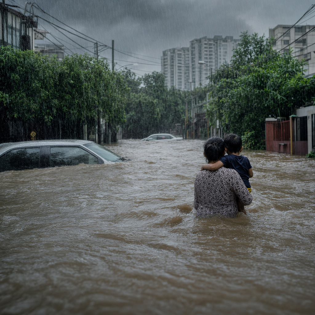
Flooding occurs when water arrives faster than the ground, drains, rivers or reservoirs can absorb or carry it away. During heavy rain, the first stage is surface runoff. Roads, rooftops and paved areas prevent infiltration, so water moves quickly into drains and low-lying zones.
In cities, the risk is intensified by concrete surfaces and encroachment on natural drainage channels. When stormwater drains are clogged by silt, plastic waste or construction debris, water can rise within minutes. Underpasses, basements and ground-floor homes are often the first places affected.
In hill districts, heavy rain can loosen slopes and trigger landslides. The risk rises when rainfall follows earlier wet spells because soil is already saturated. In river basins, heavy rainfall upstream can create floods downstream even if the downstream area receives little rain at the same time.
Coastal cities face an additional problem. If heavy rain coincides with high tide or storm surge, stormwater may not drain efficiently into the sea. This increases the duration and depth of urban flooding.
Climate Link: What Scientific Agencies Say
Scientific agencies do not attribute every single heavy rain event to climate change without formal analysis. However, the established physical relationship is clear: warmer air can hold more water vapour. The World Meteorological Organization and the Intergovernmental Panel on Climate Change have reported that a warming climate increases the likelihood and intensity of heavy precipitation in many regions.
The IPCC’s Sixth Assessment Report states that the frequency and intensity of heavy precipitation events have increased since the 1950s over most land areas where observational data are sufficient. The report attributes this mainly to human-induced climate change. This does not mean every storm will become more severe everywhere. It means the probability of heavier rainfall has increased in many regions.
For public safety, this distinction matters. Disaster planning relies on measured trends and risk mapping, not on assumptions about a single storm. Authorities combine rainfall forecasts, river levels, land-use data and historical flood records to issue warnings.
India and South Asia: Monsoon Dependence and Risk
India receives most of its annual rainfall during the southwest monsoon, normally from June to September. Heavy rain during this period is essential for agriculture, reservoirs and groundwater recharge. At the same time, extreme rainfall can cause severe losses when it arrives in concentrated bursts.
The India Meteorological Department provides daily monsoon updates, district-level warnings and rainfall departures from long-period averages. State disaster-management authorities use these alerts to plan evacuations, school closures, reservoir operations and emergency response.
South Asian cities are especially vulnerable because of population density and rapid urban expansion. Drainage networks built decades ago may not be designed for current land use or short-duration extreme rainfall. Informal settlements located near canals, rivers or marshlands face higher exposure because these areas flood first during heavy rain.
Rural areas face different risks. Heavy rainfall can damage standing crops, wash away topsoil, breach small irrigation structures and isolate villages. Where roads cross seasonal streams, sudden flow can cut access to health care and markets.
Public Health Risks After Heavy Rain
Floodwater can carry sewage, chemicals, animal waste and sharp objects. Health departments commonly warn residents not to walk through floodwater unless necessary and to avoid using contaminated water for drinking or cooking.
After heavy rain, stagnant water can increase mosquito breeding. Public-health agencies monitor dengue, malaria and other vector-borne diseases during and after the monsoon. In flooded areas, diarrhoeal disease risk can rise if drinking-water systems are contaminated.
Electricity is another hazard. Waterlogged streets can conceal live wires, damaged power infrastructure and open manholes. Disaster-management authorities frequently advise people to switch off electrical supply in flooded buildings and to avoid touching poles, transformers or fallen wires.
How Governments Prepare for Heavy Rain
Preparedness is usually divided into forecasting, public warning, infrastructure management and emergency response. Weather departments issue alerts several days in advance when models show high rainfall probability. As the event approaches, warnings are refined using radar and real-time observations.
Municipal bodies clear stormwater drains, deploy pumps and identify vulnerable locations. Reservoir managers monitor inflows and storage levels. Police and transport departments may close flooded roads, underpasses and unsafe bridges.
At the community level, schools, hospitals and local officials are often asked to prepare backup power, drinking water and evacuation routes. In high-risk zones, residents may be moved before rivers cross danger levels or before landslide risk becomes extreme.
What Residents Should Track During Heavy Rain
During heavy rain, official warnings should be checked frequently because conditions can change within hours. People in flood-prone areas should monitor local government bulletins, weather department alerts, river-level updates and road-closure notices.
Key safety steps include keeping phones charged, storing drinking water, avoiding flooded roads, moving documents to higher shelves and preparing medicines for elderly or chronically ill family members. Vehicle owners should not attempt to drive through moving water; even shallow fast-moving water can destabilise vehicles.
Residents in landslide-prone zones should watch for cracks in walls, tilting trees, sudden muddy water flow, unusual sounds from slopes and small rockfalls. These signs can indicate ground movement and require immediate evacuation based on official instructions.
Heavy Rain and Infrastructure
Roads, railways, airports and power networks are frequently affected by heavy rain. Waterlogging can damage road surfaces and disrupt traffic for hours. Rail tracks may be submerged or weakened by washouts. Airports can face delays when visibility is poor or runways are affected by standing water.
Drainage infrastructure is one of the most important defences. Well-maintained drains, restored wetlands, desilted canals and functioning pumps reduce flood depth and duration. Urban planners increasingly use flood maps to identify areas where new construction may increase runoff or block natural flow paths.
In rural areas, embankments, check dams and watershed management can reduce runoff speed and protect farms. However, poorly maintained structures can fail during extreme rainfall. Regular inspection before the monsoon is therefore part of disaster-risk reduction.
Economic Impact of Heavy Rain
The economic cost of heavy rain includes direct damage to homes, crops, vehicles, shops and public infrastructure. Indirect losses include missed workdays, transport delays, school closures, supply-chain disruption and higher repair costs for local governments.
Agriculture can benefit from well-distributed rain but suffer from intense downpours. Heavy rain can flatten crops, delay harvesting and increase fungal disease. For small farmers, a single extreme event can affect income for an entire season.
Insurance claims also rise after flood events. In many developing regions, low insurance coverage means households pay out of pocket for repairs. Government relief packages may cover immediate needs, but long-term reconstruction can take months or years depending on the scale of damage.
Why Local Data Matters
National rainfall totals can hide local extremes. A district may record normal seasonal rainfall while one town receives extreme rainfall in a few hours. This is why dense rain-gauge networks and radar coverage are important.
Local flood history is also critical. Areas that flooded in past storms are often at risk again unless drainage, land use or flood protection has changed. Community reporting, ward-level maps and real-time water-level sensors help authorities issue more precise warnings.
As of 2026, heavy rain management increasingly depends on combining meteorology with urban planning, hydrology and emergency communication. The most reliable information comes from official weather agencies, disaster-management authorities, river-monitoring bodies and verified news agencies reporting government figures.
Sources: Reuters, Government releases, publicly available data.
Comments
Post a Comment