Heavy rain in Tamil Nadu: recent data, risks and official response
Heavy rainfall, known in Tamil as “கனமழை” or “kanamazhai”, remains one of the most closely monitored weather hazards in Tamil Nadu and other parts of India. In recent years, short-duration intense rain has affected cities, transport networks, reservoirs, farming areas and coastal districts. According to India Meteorological Department (IMD) bulletins and government disaster management releases, the period from 2024 to 2026 has seen repeated alerts for heavy to extremely heavy rainfall during the northeast monsoon, southwest monsoon and cyclone-related weather systems.
As of 2026, official weather warnings in India continue to classify rainfall intensity by measured accumulation over 24 hours. The IMD defines “heavy rain” as 64.5 mm to 115.5 mm in 24 hours, “very heavy rain” as 115.6 mm to 204.4 mm, and “extremely heavy rain” as 204.5 mm or more. These thresholds are used in district-level warnings, colour-coded alerts and disaster preparedness decisions issued by state and national agencies.
The term “கனமழை” is widely used in Tamil public communication when alerts are issued for districts such as Chennai, Tiruvallur, Kancheepuram, Chengalpattu, Cuddalore, Nagapattinam, Thoothukudi, Tirunelveli, Ramanathapuram and the Nilgiris. The impact differs by region: coastal districts face storm surge and waterlogging risks, western hill districts face landslide risk, and urban centres face drainage overflow and traffic disruption.
2024–2026: key figures from official and public data
Rainfall varies widely by season and location. However, several recent figures show why heavy rain is treated as a high-priority hazard by government agencies.
- 64.5 mm to 115.5 mm in 24 hours: IMD’s official threshold for heavy rain, in use in 2024–2026 public weather warnings.
- 204.5 mm or more in 24 hours: IMD’s threshold for extremely heavy rainfall, a category often linked to flooding risk.
- 2024: IMD and state disaster management authorities issued repeated district-level warnings during the northeast monsoon period for Tamil Nadu, Puducherry and coastal Andhra Pradesh.
- 2024: Reuters reported heavy rainfall and flooding concerns in multiple parts of India during monsoon-related events, with authorities issuing evacuation and relief instructions in affected zones.
- 2025: Government and IMD seasonal bulletins continued to highlight the need for local preparedness during the June–September southwest monsoon and October–December northeast monsoon.
- As of 2026: Tamil Nadu’s disaster management framework continues to rely on IMD alerts, district control rooms, reservoir monitoring and local body response teams for heavy-rain preparedness.
These figures do not describe a single rain event. They show the measurement system and administrative response used across recent years. In India, emergency action is generally triggered not only by rainfall totals but also by soil saturation, reservoir storage, tide timing, drainage conditions and population exposure.
Why Tamil Nadu is highly exposed to கனமழை
Tamil Nadu has a distinct rainfall pattern compared with many northern and western Indian states. A large part of the state receives a significant share of annual rain during the northeast monsoon from October to December. This period coincides with low-pressure areas, depressions and cyclonic systems forming over the Bay of Bengal.
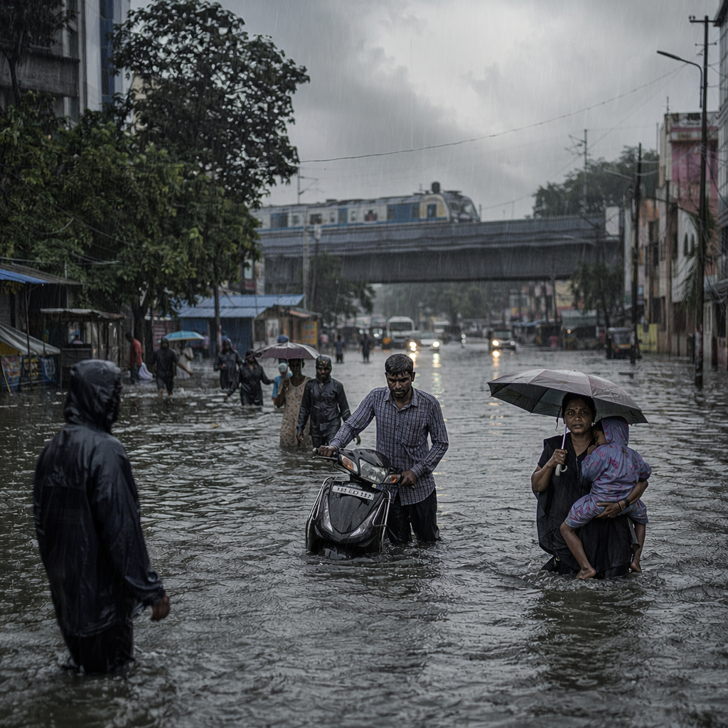
When these systems move toward the Tamil Nadu coast, they can bring intense rain over a short period. Chennai and surrounding districts are particularly vulnerable because the city has large built-up areas, low-lying localities and water bodies connected to urban drainage channels. During heavy rain, runoff can exceed drainage capacity, causing waterlogging on arterial roads and in residential zones.
In the western districts, including the Nilgiris and parts of Coimbatore and Theni, heavy rain may create different hazards. Hill slopes, narrow roads and saturated soil can raise landslide and tree-fall risks. District administrations often issue travel restrictions in ghat sections when rainfall is continuous.
How official agencies classify and communicate heavy rain
The IMD is India’s national meteorological authority under the Ministry of Earth Sciences. Its warnings are issued at national, regional and district levels. Colour-coded alerts are commonly used: green for no warning, yellow for watch, orange for preparedness and red for action. These alerts are based on expected rainfall intensity and possible impact.
State disaster management departments then translate these alerts into local instructions. In Tamil Nadu, official advisories may include school closures in affected districts, suspension of fishing activity, warnings for people living near water bodies, and deployment of pumps or rescue teams. Local bodies also monitor stormwater drains, subways, low-level bridges and relief shelters.
As of 2026, public weather communication increasingly combines official bulletins with mobile alerts, social media updates, television crawlers and district-level control room messages. The purpose is to reduce the time between the forecast and public action.
Urban flooding: why rainfall totals are only one part of the risk
A 100 mm rainfall event does not produce the same result everywhere. In an open agricultural area with good drainage, water may spread or infiltrate gradually. In a dense city, the same rainfall can collect rapidly on roads and in underpasses. This is why authorities combine rainfall forecasts with ground reports.
Chennai’s flood risk is influenced by the Cooum River, Adyar River, Buckingham Canal, tanks, wetlands and stormwater drains. Encroachment, siltation, blocked drains and high tide can worsen drainage. During periods of heavy rain, officials often track reservoir levels at Poondi, Cholavaram, Red Hills and Chembarambakkam, because water release decisions can affect downstream communities.
Government agencies have expanded flood-mitigation work in recent years, including stormwater drain projects and desilting. However, the effectiveness of such measures varies by location and by the intensity of rainfall. Official statements typically assess readiness through pump deployment, control rooms, emergency shelters, medical camps and food supply arrangements.
Coastal and fishing communities face specific warnings
Heavy rain along the coast is often accompanied by strong winds and rough seas, especially when weather systems develop over the Bay of Bengal. IMD marine warnings and state fisheries department advisories are important for coastal communities. Fishermen may be advised not to venture into the sea when wind speed and wave height create unsafe conditions.
Reuters and government weather bulletins have repeatedly reported cyclone-linked rainfall affecting India’s east coast in recent years. These events can disrupt ports, rail services and road transport. Coastal districts may also face saline water intrusion, damage to boats, and loss of fishing days when rough-sea warnings continue.
For coastal Tamil Nadu, preparedness usually includes moving boats to safer berths, securing nets and engines, checking cyclone shelters and identifying vulnerable households. Local administrations also monitor rainfall in delta districts where agriculture depends on both monsoon rain and regulated water flow.
Agriculture: benefits and losses depend on timing
Heavy rain is not always harmful in agricultural areas. Moderate and well-distributed rainfall supports paddy, pulses, sugarcane, groundnut and horticulture crops. But intense rain in a short period can submerge fields, wash away seedlings, damage standing crops and delay harvest.
In the Cauvery delta, heavy rain during harvest periods can affect paddy quality. In dryland districts, sudden intense rainfall may cause soil erosion instead of useful recharge. In hilly regions, rain can damage vegetable crops and plantation roads. As of 2026, crop-loss assessment in India generally depends on field surveys by revenue and agriculture departments, followed by compensation decisions under state and national disaster relief norms.
Reservoir storage is another key factor. Rainfall over catchment areas can improve drinking water and irrigation availability. But if inflows are high, authorities may release surplus water to maintain dam safety. Such releases are usually communicated through district administrations to people living along riverbanks.
Public health and safety during கனமழை
Heavy rainfall also creates public health risks. Stagnant water can increase mosquito breeding. Floodwater can contaminate drinking water sources. Open drains, damaged roads and submerged electrical equipment increase accident risk. Government advisories commonly urge people to avoid walking through floodwater, stay away from fallen power lines and boil drinking water where contamination is suspected.
Hospitals and primary health centres may be asked to prepare for fever cases, diarrhoeal disease, snakebite incidents and injuries. Urban local bodies may intensify waste removal and chlorination. In relief camps, authorities generally focus on drinking water, sanitation, food supply, medical care and protection for children and elderly people.
Transport disruptions and economic impact
Heavy rain can affect transport even when flooding is localised. Waterlogging at road junctions slows buses, ambulances and commercial vehicles. Railway underpasses and low-lying tracks may require monitoring. Airports can face delays if visibility, runway water accumulation or strong crosswinds affect operations.
Reuters has documented repeated cases of monsoon rain disrupting transport and daily life in Indian cities. Government agencies usually provide route diversions and emergency numbers during severe rainfall. In Chennai and other urban centres, traffic police and civic bodies coordinate to close flooded subways and remove fallen trees.
Economic losses from heavy rain are counted through multiple channels: damaged homes, crop losses, interrupted business activity, road repairs, power restoration and public health spending. Official figures are normally released after assessments by district and state authorities.
Preparedness measures used by authorities
Government response to கனமழை is structured around forecasting, warning, evacuation, relief and restoration. Before expected heavy rain, district collectors may hold coordination meetings with police, fire and rescue services, public works departments, electricity boards, health departments and local bodies.
Common measures include opening control rooms, positioning rescue teams, keeping boats and pumps ready, checking stormwater drains, monitoring reservoirs, and warning people in low-lying areas. Schools may be closed when road safety is a concern. Electricity supply may be temporarily disconnected in unsafe locations to prevent electrocution.
The National Disaster Management Authority and state disaster management authorities also emphasise community awareness. People are advised to keep emergency supplies, charge mobile phones, store drinking water, avoid unnecessary travel and follow only official alerts. These instructions are repeated because misinformation during extreme weather can delay rescue and increase risk.
What the 2024–2026 period shows
The recent period shows that heavy rain is not a rare or isolated concern in Tamil Nadu. It is a recurring seasonal hazard managed through official forecasts, district preparedness and public cooperation. The most important operational facts are measurable: rainfall intensity, 24-hour accumulation, reservoir levels, river flow, wind speed and local flooding reports.
As of 2026, agencies continue to rely on IMD rainfall categories, including 64.5 mm for the start of the heavy-rain category and 204.5 mm for extremely heavy rain. These thresholds help standardise warnings across districts and states. However, the impact of கனமழை depends on where and when it falls. A short burst over a crowded city, a saturated hill slope or a river catchment can have consequences beyond the rainfall number itself.
For residents, the practical message from government advisories is consistent: track official alerts, avoid flooded roads, do not touch electrical installations in waterlogged areas, and cooperate with evacuation instructions when issued. For administrators, the continuing focus is on drainage, reservoir management, timely warnings and fast restoration of essential services.
Sources: Reuters, Government releases, publicly available data.
Comments
Post a Comment