Earthquakes in 2026: What Recent Data Shows About Risk, Damage and Preparedness
As of 2026, earthquakes remain one of the world’s fastest-moving natural hazards, capable of causing mass casualties and infrastructure losses within seconds. According to the U.S. Geological Survey (USGS), the planet experiences about 500,000 detectable earthquakes each year, although roughly 100,000 are felt and about 100 cause damage. The figures underline why seismic monitoring, building standards and emergency planning continue to be central public-safety issues for governments in high-risk regions.
Recent disasters have shown that earthquake risk is not measured by magnitude alone. Depth, population density, construction quality, time of day and local ground conditions can determine whether a tremor becomes a major humanitarian emergency. From Japan’s Noto Peninsula earthquake in 2024 to Taiwan’s Hualien earthquake in 2024 and continuing aftershock management in Türkiye and Syria following the 2023 disaster, official data show that the human and economic consequences of seismic events remain severe.
What Is an Earthquake?
An earthquake occurs when stress built up along faults in the Earth’s crust is suddenly released, producing seismic waves. The movement can be caused by tectonic plate boundaries, volcanic activity or human-induced processes such as reservoir loading and some forms of underground extraction. Most damaging earthquakes occur along tectonic plate boundaries, including the Pacific “Ring of Fire,” the Himalayan belt and the Alpide belt stretching from Europe into Asia.
Scientists measure earthquake size using magnitude scales, most commonly moment magnitude, which estimates the energy released at the source. The effects people experience at the surface are described using intensity scales, such as the Modified Mercalli Intensity scale. A magnitude 7.0 earthquake can have very different outcomes depending on whether it strikes offshore, deep underground, or directly beneath a city with vulnerable buildings.
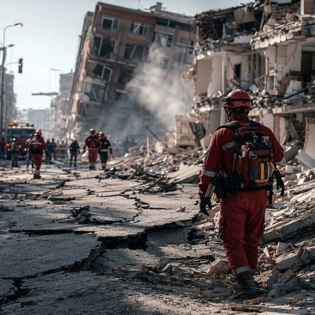
Recent Earthquakes Show the Scale of the Risk
On 1 January 2024, a magnitude 7.5 earthquake struck Japan’s Noto Peninsula, according to the Japan Meteorological Agency and the USGS. Japanese authorities reported hundreds of deaths, extensive building damage, landslides, fires and long-running disruption to roads, water systems and power supply. Reuters reported that rescue efforts were complicated by damaged roads and winter conditions, while government agencies continued damage assessments through 2024.
Japan’s experience also highlighted the importance of warning systems and public preparedness. The country operates one of the world’s most advanced earthquake early-warning networks, issuing alerts through television, mobile phones and public systems. Even so, strong ground motion, tsunami warnings and infrastructure damage showed that technology can reduce risk but cannot eliminate it.
On 3 April 2024, Taiwan was hit by a magnitude 7.4 earthquake near Hualien, according to the USGS. It was widely reported as Taiwan’s strongest earthquake in about 25 years. Reuters, citing Taiwan authorities, reported deaths, hundreds of injuries, building damage and landslides that trapped people in tunnels and mountainous areas. Taiwan’s strict building codes and emergency-response systems were credited by officials with limiting casualties compared with past events, while inspections continued on transport links and buildings.
In Iceland, seismic activity during 2024 was closely linked to volcanic unrest on the Reykjanes Peninsula. The Icelandic Meteorological Office reported repeated earthquake swarms associated with magma movement, prompting evacuations and infrastructure protection efforts around the town of Grindavík. Although many of these events were smaller than major tectonic earthquakes, the 2024 sequence demonstrated how seismic monitoring can be used to manage volcanic and ground-deformation hazards.
Key Earthquake Statistics From 2024–2026
Public data from scientific and government agencies provide measurable indicators of current earthquake exposure and response capacity. The following figures are drawn from agencies including the USGS, Japan Meteorological Agency, Taiwan authorities, Icelandic Meteorological Office, the United Nations and national disaster-management bodies.
- 2024: The USGS measured the Noto Peninsula earthquake in Japan at magnitude 7.5 on 1 January 2024, while Japanese government agencies reported widespread infrastructure damage and prolonged emergency operations.
- 2024: The USGS recorded Taiwan’s Hualien earthquake at magnitude 7.4 on 3 April 2024; Reuters reported fatalities, more than 1,000 injuries and major landslides based on official Taiwanese data.
- 2024: The Icelandic Meteorological Office reported thousands of earthquakes in swarms on the Reykjanes Peninsula during volcanic unrest, including repeated evacuations and road closures around Grindavík.
- 2024: The USGS continued to state that about 500,000 earthquakes are detectable worldwide each year, with roughly 100,000 felt by people.
- 2025: National and local governments in high-risk countries continued post-disaster reconstruction and seismic-retrofit programmes, including Japan’s damage assessments after the 2024 Noto earthquake and Türkiye’s rebuilding following the 2023 Kahramanmaraş earthquakes, according to government releases and Reuters reporting.
- As of 2026: Global earthquake monitoring remains led by networks including the USGS National Earthquake Information Center, Japan Meteorological Agency, European-Mediterranean Seismological Centre and national geological agencies that publish real-time or near-real-time seismic data.
Why Some Earthquakes Are More Destructive Than Others
Magnitude is only one factor in earthquake damage. A shallow magnitude 6.5 earthquake near a city can be more destructive than a deeper magnitude 7.5 event far offshore. Ground shaking is amplified in soft sediments, reclaimed land and river basins, while steep terrain can trigger landslides. Coastal earthquakes may also generate tsunamis if seafloor displacement occurs.
Building vulnerability is often the decisive factor. The World Bank and the United Nations Office for Disaster Risk Reduction have repeatedly identified unsafe construction as a major driver of earthquake deaths. Buildings made without seismic design, with weak columns, poor concrete or unreinforced masonry, are more likely to collapse during strong shaking. By contrast, countries with strict enforcement of seismic codes generally record lower casualty rates for comparable shaking levels.
Urbanization has increased exposure. As of 2024, United Nations data showed that more than half of the world’s population lived in urban areas, many of them in large cities located near active faults. Rapid construction, informal settlements and ageing infrastructure can increase risk unless matched by code enforcement and retrofitting.
How Governments Monitor Earthquakes
Modern earthquake monitoring relies on dense networks of seismometers, GPS stations, ocean buoys, satellite observations and automated data systems. When an earthquake occurs, seismic waves are detected by instruments and rapidly analyzed to estimate magnitude, depth, location and likely shaking intensity. Agencies then issue public bulletins and alerts.
In the United States, the USGS operates the National Earthquake Information Center and publishes near-real-time earthquake information. Japan’s Meteorological Agency issues earthquake early warnings and tsunami advisories. Taiwan’s Central Weather Administration monitors seismic activity and publishes official alerts. The European-Mediterranean Seismological Centre provides regional earthquake information for Europe and surrounding areas.
Early-warning systems do not predict earthquakes. Instead, they detect the first, faster seismic waves and send alerts before stronger shaking arrives. Depending on distance from the epicenter, warning time may range from a few seconds to tens of seconds. That can be enough to slow trains, stop elevators, shut industrial systems and allow people to take protective action.
Earthquake Preparedness in 2026
As of 2026, disaster agencies continue to emphasize preparedness at household, building and city levels. The U.S. Federal Emergency Management Agency, Japan’s Cabinet Office, and other government bodies advise people in seismic zones to secure heavy furniture, know safe spots indoors, store emergency supplies and follow official evacuation instructions after strong shaking or tsunami warnings.
Preparedness also includes infrastructure planning. Hospitals, schools, bridges, ports, power substations and water systems must remain functional after earthquakes. Governments and engineering bodies use hazard maps to guide land use, building design and retrofit priorities. After major earthquakes, authorities typically inspect bridges, rail lines, dams, nuclear facilities, high-rise buildings and communications networks.
Insurance and financial planning are also part of resilience. Earthquake damage is often not covered by standard property insurance policies in many countries unless specific earthquake coverage is purchased. Public disaster funds, international aid and reconstruction budgets can take years to resolve after major events.
Humanitarian and Economic Impact
The cost of earthquakes extends beyond collapsed buildings. Major events can disrupt supply chains, tourism, energy systems, ports and manufacturing. In Japan’s 2024 Noto Peninsula earthquake, damaged roads and remote terrain slowed rescue and recovery work. In Taiwan’s 2024 Hualien earthquake, landslides affected transport routes and trapped people in mountainous areas. In both cases, government agencies and emergency services worked through aftershocks, unstable slopes and damaged infrastructure.
The 2023 Türkiye-Syria earthquake sequence remains one of the clearest recent examples of long-term impact. Although it occurred before 2024, reconstruction and displacement continued into 2024 and 2025. The United Nations, World Bank and national authorities reported massive housing, infrastructure and livelihood losses after the February 2023 earthquakes, with rebuilding continuing across affected provinces.
These cases show why current earthquake policy is focused on risk reduction before disaster strikes. Search-and-rescue capacity is important, but engineering standards, land-use planning, public education and rapid alert systems are the measures most consistently linked by disaster agencies to reduced casualties.
Can Earthquakes Be Predicted?
No government scientific agency currently claims the ability to predict the exact time, location and magnitude of future earthquakes. The USGS states that neither it nor any other scientists have ever predicted a major earthquake in a precise and reliable way. What scientists can produce are hazard assessments, probability models and aftershock forecasts based on geology, fault history and seismic patterns.
After a large earthquake, aftershock forecasts are especially useful. They estimate the probability of additional earthquakes in the affected area over days, weeks or months. Authorities use these forecasts to guide rescue operations, building inspections and public warnings. However, forecasts are not guarantees; they describe changing probabilities, not certainties.
What the Data Means for High-Risk Regions
As of 2026, the main lesson from recent earthquakes is that risk is concentrated where active faults intersect with vulnerable buildings and dense populations. Countries including Japan, New Zealand, Chile, Mexico, Indonesia, Türkiye, Iran, the United States, Taiwan, Nepal and the Philippines maintain seismic monitoring and emergency-management systems because of their known exposure to active tectonic zones.
Government and scientific data show that damage reduction depends on practical measures: updated building codes, enforcement, retrofitting, public drills, tsunami planning and real-time alerts. The 2024 earthquakes in Japan and Taiwan demonstrated both the value and limits of preparedness. Strong institutions and codes can reduce casualties, but major shaking can still overwhelm roads, older buildings, slopes and lifeline infrastructure.
For residents in earthquake-prone areas, the official guidance remains consistent across agencies: drop, cover and hold on during shaking; move to higher ground after a tsunami warning; avoid damaged buildings; expect aftershocks; and rely on verified information from government and scientific authorities.
Sources: Reuters, Government releases, publicly available data.
Comments
Post a Comment