Delhi NCR in 2026: India’s Capital Region Measured in Numbers
Delhi National Capital Region, or Delhi NCR, is one of India’s largest urban agglomerations, with more than 46,000 square kilometres under the National Capital Region Planning Board framework and a population base that continues to shape transport, housing, employment and environmental policy. As of 2026, the region remains central to India’s governance and economy because it includes the National Capital Territory of Delhi and major districts of Haryana, Uttar Pradesh and Rajasthan.
The NCR is not a single city. It is a legally defined planning region under the National Capital Region Planning Board Act, 1985. According to the NCR Planning Board under the Ministry of Housing and Urban Affairs, the region covers 55,083 square kilometres after revisions notified in recent years. It includes the entire NCT of Delhi and selected districts such as Gurugram, Faridabad, Noida, Ghaziabad, Meerut, Sonipat, Panipat, Alwar and Bharatpur, among others. This makes Delhi NCR a multi-state urban region where policy decisions often involve the Union government and four state governments.
The latest full Census population figure for Delhi is from 2011, when the National Capital Territory had 16.8 million people, according to the Office of the Registrar General and Census Commissioner of India. Since the 2021 Census was not completed on schedule, official population estimates for 2024–2026 rely on projections and administrative datasets. The United Nations’ World Urbanization Prospects 2024 placed the Delhi urban agglomeration among the world’s largest, with an estimated population of more than 33 million in 2024. These figures help explain why the NCR’s infrastructure planning is linked to migration, commuting and land use across state borders.
Administrative and Economic Weight
Delhi NCR includes India’s national capital, the seat of Parliament, the Supreme Court of India, central ministries, foreign missions and major corporate offices. The NCT of Delhi’s economy is dominated by services, trade, transport, construction, finance, real estate and public administration.
According to the Government of NCT of Delhi’s Economic Survey 2023–24, Delhi’s Gross State Domestic Product at current prices was estimated at about ₹11.07 lakh crore in 2023–24. The same government data placed Delhi’s per capita income at about ₹4.61 lakh in 2023–24, among the highest for Indian states and union territories. The survey attributed a large share of output to the services sector, consistent with Delhi’s role as a political, administrative and commercial centre.
Neighbouring NCR districts also play an important role. Gurugram is a major hub for information technology, business services, automobile companies and real estate. Noida and Greater Noida host electronics manufacturing, media companies, information technology parks and educational institutions. Ghaziabad, Faridabad and Sonipat are linked to manufacturing, warehousing and industrial corridors. Government and industry data show that the region’s labour market depends heavily on daily inter-city travel, with commuters crossing Delhi’s borders for work and education.
Transport: Metro, Expressways and Regional Rail
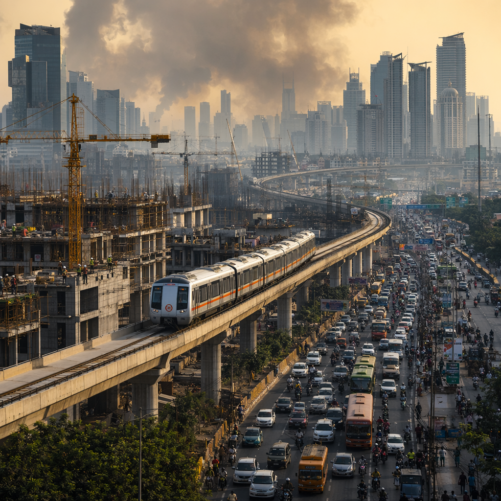
Transport is the clearest indicator of how integrated Delhi NCR has become. The Delhi Metro Rail Corporation reported that, by 2024, the Delhi Metro network had crossed 390 kilometres of operational routes with 288 stations, including corridors extending into Noida, Ghaziabad, Gurugram, Faridabad and Bahadurgarh. The metro has become the backbone of daily commuting in the region.
In February 2024, DMRC said the Delhi Metro recorded its then-highest passenger journeys, with more than 7.1 million passenger journeys in a single day. The figure reflected ridership recovery and growth after the COVID-19 period. Metro expansion under Phase IV continued in 2024 and 2025, with new corridors planned to connect outer Delhi and improve links to high-density areas.
Delhi NCR is also the site of India’s first Regional Rapid Transit System. The National Capital Region Transport Corporation opened priority sections of the Delhi–Ghaziabad–Meerut RRTS corridor in phases from 2023. As of 2026, the corridor is being expanded toward full operation between Delhi, Ghaziabad and Meerut. The planned corridor length is about 82 kilometres, according to NCRTC, and the trains are designed for speeds up to 180 kilometres per hour. The project is intended to reduce travel time between Delhi and Meerut and support commuting beyond the metro’s urban core.
Road infrastructure remains extensive but congested. The Delhi–Meerut Expressway, Eastern Peripheral Expressway, Western Peripheral Expressway, Delhi–Mumbai Expressway links and urban flyovers have changed travel patterns around the NCR. However, official traffic and environment reports continue to connect road transport to congestion, particulate pollution and rising vehicle ownership.
Air Quality: A Persistent Public Health Challenge
Air pollution remains one of Delhi NCR’s most closely tracked public policy issues. The Central Pollution Control Board and the Commission for Air Quality Management publish regular air quality data and control measures for the region. The problem is seasonal but not limited to winter. Sources include transport emissions, construction dust, road dust, industrial activity, waste burning, household fuel use in some areas and seasonal crop-residue burning in neighbouring states.
In January 2024, Reuters reported that Delhi’s air quality repeatedly entered the “severe” category during winter pollution episodes, citing Indian monitoring agencies. In November 2024, authorities implemented restrictions under the Graded Response Action Plan when the Air Quality Index crossed hazardous thresholds in parts of the NCR. The AQI scale used by Indian agencies classifies 401–500 as “severe”, a level at which health warnings apply to the general population.
According to the Ministry of Environment, Forest and Climate Change, the Commission for Air Quality Management coordinates NCR-wide measures, including restrictions on polluting fuels, construction controls during severe episodes, industrial fuel standards and directions for dust control. In 2024 and 2025, CAQM continued to issue directions under the Graded Response Action Plan as winter pollution episodes developed.
Some official data show long-term changes. The Government of India has said that Delhi’s annual average PM2.5 concentration declined compared with levels recorded in the middle of the previous decade, under measures linked to the National Clean Air Programme and local interventions. However, Delhi and several NCR cities continued to be among India’s most polluted urban centres in annual datasets published by monitoring agencies and independent research organisations using government station data.
Key 2024–2026 Indicators for Delhi NCR
- 55,083 sq km: Area of the National Capital Region under the NCR Planning Board framework, according to Government of India planning documents.
- ₹11.07 lakh crore in 2023–24: Estimated Gross State Domestic Product of Delhi at current prices, according to the Delhi Economic Survey 2023–24.
- ₹4.61 lakh in 2023–24: Estimated per capita income of Delhi, according to the Government of NCT of Delhi.
- 390+ km in 2024: Operational Delhi Metro network length, according to Delhi Metro Rail Corporation information.
- 82 km: Planned length of the Delhi–Ghaziabad–Meerut RRTS corridor, according to NCRTC project data.
- 401–500 AQI: “Severe” air quality category used by Indian pollution-control agencies, relevant to NCR pollution restrictions in 2024–2026.
Housing and Urban Expansion
Delhi NCR’s housing market is divided between planned public-sector colonies, private apartments, unauthorized colonies, urban villages, plotted housing, slum settlements and new townships. Demand is shaped by jobs, transport access, household incomes and land prices. Noida, Greater Noida, Gurugram, Faridabad, Ghaziabad and Sonipat have absorbed a large share of new residential construction because land availability within Delhi is limited.
Government data show that Delhi has a high level of urbanization. The 2011 Census classified Delhi as more than 97 percent urban. Since then, administrative expansion in surrounding NCR districts has continued through new sectors, industrial townships and expressway-linked real estate. As of 2026, major development corridors include Dwarka Expressway, Noida-Greater Noida Expressway, Yamuna Expressway, Delhi-Mumbai Expressway influence zones and the Kundli-Manesar-Palwal belt.
Housing regulation differs by state and authority. Delhi Development Authority controls large parts of land planning in Delhi, while Noida Authority, Greater Noida Authority, Yamuna Expressway Industrial Development Authority, Haryana Shahari Vikas Pradhikaran and local urban bodies regulate development outside Delhi. The Real Estate Regulatory Authority system applies separately in Delhi, Haryana, Uttar Pradesh and Rajasthan, which means buyers and developers interact with different state-level RERA offices.
Water, Power and Basic Services
Water supply in Delhi NCR is managed through multiple agencies. Delhi Jal Board supplies water within the NCT, drawing from the Yamuna, Ganga canal system, Bhakra storage and groundwater sources. Several NCR cities depend on a mix of canal water, groundwater and municipal systems. Official reports have repeatedly identified groundwater depletion in parts of Delhi, Gurugram, Faridabad, Ghaziabad and Noida as a long-term concern.
In power supply, Delhi is served by distribution companies regulated by the Delhi Electricity Regulatory Commission. The city has one of India’s larger urban electricity systems, with peak demand rising in summer. In 2024, Delhi’s power distribution companies and government agencies reported peak electricity demand above 8,000 MW during the summer, driven by heat and cooling demand. This figure was reported by Indian government-linked power agencies and utilities and was widely cited by news organisations including Reuters and Indian media outlets.
Waste management is another major NCR issue. Delhi’s municipal solid waste is processed through landfill sites, waste-to-energy plants, biomethanation, composting and material recovery systems. The Municipal Corporation of Delhi has continued work on legacy waste at landfill sites such as Ghazipur, Bhalswa and Okhla. Neighbouring NCR cities face similar pressures as population and construction activity increase.
Climate and Heat Stress
Delhi NCR experiences severe summer heat, a monsoon season, a post-monsoon pollution period and cold winters. The India Meteorological Department recorded extreme heat in northwest India in 2024. In May 2024, Delhi stations reported temperatures above 45°C during a prolonged heatwave, and some readings in the region approached record levels. IMD bulletins linked these conditions to heatwave warnings across Delhi, Haryana, Rajasthan and Uttar Pradesh.
Heat affects power demand, public health, labour productivity and water use. The Delhi government and municipal agencies issue heat-related advisories, while hospitals prepare for heat illness during severe periods. As of 2026, climate adaptation in the NCR includes heat action planning, urban greening, water-body restoration, drainage upgrades and emergency response systems, though implementation varies across local jurisdictions.
Governance Across Multiple States
One reason Delhi NCR is difficult to manage is its administrative structure. Delhi has an elected government, municipal bodies and the Union government’s direct role through the Lieutenant Governor and central agencies. Haryana, Uttar Pradesh and Rajasthan manage their respective NCR districts through state departments, development authorities and municipal corporations. Regional matters such as air pollution, transport integration, land use, water supply and waste often require coordination.
The NCR Planning Board prepares regional plans and supports infrastructure financing. The Commission for Air Quality Management oversees air-pollution directions across the region. NCRTC manages rapid rail development. DMRC operates metro corridors that cross state borders through agreements with state governments and local authorities. This layered structure is a defining feature of Delhi NCR as of 2026.
Why Delhi NCR Matters in 2026
Delhi NCR’s importance comes from measurable scale: a large population, a high-value services economy, one of the world’s larger metro systems, expanding rapid rail, high electricity demand, and persistent air-quality risks. It is also a region where national policy is visible at street level, from pollution controls and public transport expansion to real estate regulation and urban planning.
The region’s future development will be shaped by official decisions on land use, transit-oriented development, industrial location, clean fuels, water security, waste processing and climate resilience. For residents and businesses, the key measurable issues remain commute time, air quality, housing affordability, summer heat, reliable utilities and access to jobs across state borders.
Sources: Reuters, Government releases, publicly available data.
Comments
Post a Comment